Immigration raids - maps & reports
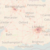
Raids heat map
This heat map shows areas across the UK where 6 or more immigration raids occurred between 1st January 2022 and 30th September 2023. The darker an area is, the more raids occurred in that area. We gained this data through FOI requests to the Home Office, which was broken down by postcode.Read more
Raids report
Our new report Immigration Raids: An Anatomy of Racist Intimidation dissects the secretive and opaque nature of Immigration Enforcement’s intelligence gathering, guidance on multi-agency operations and police cooperation.

Reporting tool and map
Use this form to log immigration raids in your area. The information from this form will be checked weekly and imported into this map.
Viewing Recommendations
The heat map is best viewed on a desktop or laptop with a good network speed. Expect sluggish performance when viewing the Maps on small mobile devices, over slower networks.